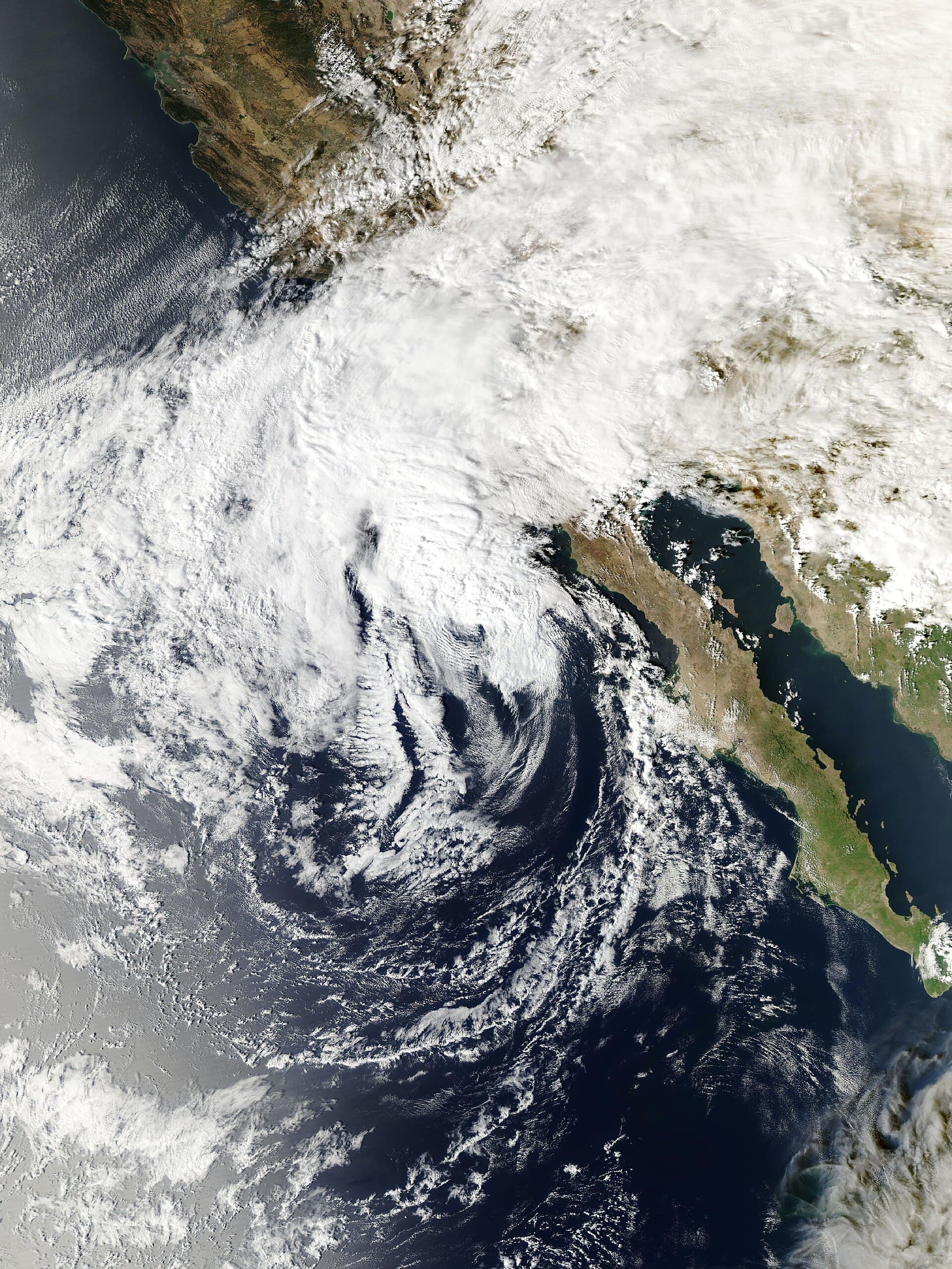
What was left of Rachel raced north across Southern California overnight and early Sunday. It set off a string of flash flood warnings from East County San Diego to the Coachella Valley, Imperial County, Blythe and Death Valley, and it closed two highways. At 5 a.m. Sunday, the National Hurricane Center placed the center of Post-Tropical Cyclone Rachel about 130 miles northeast of San Diego, moving north near 25 mph with maximum sustained winds near 40 mph. The center said Rachel "should continue to weaken and dissipate later today."
The National Weather Service office in San Diego said at 5:37 a.m. that the storm's low-level circulation had "moved well to the north into the Mojave Desert, moving much faster than the models anticipated," and that "most of the strongest winds and widespread rainfall is now behind us." Another wave of rain was moving through as of 5:30 a.m., and forecasters expected it to break into scattered showers during the morning. A Flood Watch stays in effect until 8 p.m. Sunday for all of San Diego County, the Riverside and San Bernardino county mountains, the Coachella Valley, the San Gorgonio Pass, and the Apple and Lucerne valleys. Forecasters expect the heaviest rain through early afternoon, tapering off from south to north, with lighter showers into Monday.
Flash flood warnings followed the storm north through the night. The weather service warned El Cajon, Santee, Alpine, Tierrasanta, Crest and Rancho San Diego from 11:19 p.m. Saturday until 1:15 a.m. It then warned Indio, Palm Desert, Coachella, Rancho Mirage, La Quinta, Mecca and Highway 74 between Anza and Palm Desert from 1:17 a.m. to 4:15 a.m. At 4:02 a.m. it warned San Clemente, Dana Point, Laguna Niguel, San Juan Capistrano, Rancho Santa Margarita, Coto de Caza and the Ortega Highway until 7 a.m., saying up to 1 inch of rain had fallen there. The Phoenix office issued warnings across Imperial County, including El Centro, Calexico and Brawley overnight, and a warning for Blythe until 8:30 a.m. The Las Vegas office warned of life-threatening flash flooding at Furnace Creek and Stovepipe Wells in Death Valley National Park until 7:30 a.m. It also issued flood advisories for Twentynine Palms, Yucca Valley, Joshua Tree and Baker, saying 1 to 2 inches had fallen in parts of the Morongo Basin.
The weather service's preliminary two-day totals, through 6:18 a.m. Sunday, were heaviest in the mountains and low desert of San Diego and Riverside counties. Palomar CRS on Palomar Mountain recorded 3.89 inches, Birch Hill 3.83, Cactus City in the Coachella Valley 3.07 and Bear Creek 2.95. Lower down, Carlsbad recorded 1.65 inches, Ramona Airport 2.14, Riverside's March Air Reserve Base 1.18, Palm Springs Airport 1.12 and San Diego International Airport 0.84. The weather service said the gauge data is provisional. Los Angeles County stayed much drier. The Oxnard office's top total through 5 a.m. was 0.55 inch at Crystal Lake in the San Gabriel Mountains.
Caltrans closed US 95 in both directions from Interstate 10 to the Nevada state line because of flooding, District 8 said in a 4:45 a.m. post. The district gave no estimate for reopening. Caltrans highway information as of 6:47 a.m. also listed eastbound Interstate 8 closed 4.5 miles east of El Cajon because of flooding. A high wind advisory covered I-8 from San Diego County to Imperial County, and Caltrans said travel was not recommended for campers, trailers or permit loads.
Wind was the other overnight hazard. The San Diego office said sustained winds of 59 mph were observed in the southern and eastern parts of San Diego County, with stronger gusts in thunderstorms. Wind advisories remain in effect until 5 a.m. Monday for the San Diego, Riverside and San Bernardino county mountains and deserts. Forecasters expect ridge and desert-slope gusts of about 30 to 50 mph, locally higher, through Sunday evening. The Los Angeles office has wind advisories up for the San Gabriel Mountains and Antelope Valley, with gusts of 35 to 50 mph and local gusts near 60 mph.
The coast faces its most serious test with Sunday morning's high tide. Coastal flood warnings run until 3 p.m. for the Los Angeles County beaches, the Malibu coast, Catalina, and the Orange County and San Diego County coasts. Coastal flood advisories follow through 2 p.m. Tuesday. The Los Angeles office expects tides near 8 feet Sunday morning, nearly 2 feet above the astronomical high tide of 6.1 feet. It said such tides "would approach or exceed recent record tide levels for LA county." It warned that south-facing beaches such as Alamitos Peninsula and Naples in Long Beach, as well as Malibu, could see significant sea-water flooding that damages coastal structures and beach roads. Saturday morning, NOAA's Los Angeles tide gauge peaked at 7.69 feet above mean lower low water at 9:48 a.m., and the San Diego gauge reached 8.06 feet at 9:30 a.m. In San Diego and Orange counties, forecasters expect surf of 5 to 8 feet with sets to 9 feet and morning high tides of 7 to 7.5 feet.
Long Beach has been hit hardest so far. The city has proclaimed a local emergency. A mandatory evacuation order remains in effect for oceanfront homes in the 6400 and 6500 blocks of Seaside Walk, and an evacuation warning covers nearby blocks. City inspectors have red-tagged eight buildings with 13 residences after waves overtopped the Peninsula bulkhead, and the Peninsula is closed to nonresidents.
In San Diego, the weather service forecast the San Diego River at Fashion Valley to crest at 8.1 feet just before noon Sunday. That is above the 7.5-foot action stage, when low-lying roads around Fashion Valley Mall begin to take on water and Avenida Del Rio floods first, but below the 10-foot flood stage. The U.S. Geological Survey gauge there read 5.54 feet at 6:15 a.m., up from 2.33 feet Saturday evening.
Burn-scar risk appeared limited Sunday morning. As of about 6:50 a.m., the weather service had not issued a flood watch, flood advisory or flash flood warning for Los Angeles County, including the Eaton and Palisades burn areas. The Los Angeles office expects 0.25 to 1 inch in the county through Monday night and up to 2 inches in the San Gabriel Mountains. It said rain rates should generally stay below 0.25 inch per hour, with local rates near 0.50 inch per hour that "could generate some minor hydrologic issues." In southern Orange County, the weather service's Bell Canyon gauge recorded 2 inches. The Orange County Sheriff's Department says its evacuation planning for flash flood watches and warnings there covers Trabuco Creek, Bell Canyon and Hot Springs Canyon. Its Airport Fire page did not show an active evacuation Sunday morning.
State officials positioned crews before the storm under the statewide El Niño emergency Gov. proclaimed in September. The Governor's Office of Emergency Services said Friday it was staging a swift water rescue team, two fire engines, a hand crew and 35 firefighters, dispatchers and support personnel in San Bernardino County for Rachel. GCJ had not confirmed any storm-related swiftwater rescues from official agencies as of 7 a.m. Sunday.
Northern California is dry and, in places, under fire weather instead. The Sacramento office has a Red Flag Warning from 7 a.m. Sunday to 5 a.m. Monday for the Redding area and parts of Tehama and Glenn counties, with gusts up to 30 to 40 mph and humidity as low as 15%. Around San Francisco and Monterey bays, a coastal flood advisory runs through 3 p.m. Tuesday. The San Francisco tide gauge is expected to reach 7.3 feet at 12:18 p.m. Sunday.
After Sunday, scattered showers are expected across the coastal basin Monday as a trough moves through, with about 0.05 to 0.25 inch of rain and light snow above about 8,000 feet, the San Diego office said. Showers should clear by Tuesday afternoon. Forecasters then expect a sharp turnaround: highs back in the 80s at lower elevations by Thursday, possibly 90s at the coast Friday and Saturday with offshore winds, and a growing chance of moderate Santa Ana winds in Ventura and Los Angeles counties Friday, according to the Los Angeles office. Minor to moderate coastal flooding remains possible with morning high tides near 7.5 feet in Los Angeles County through Tuesday.

State
Gavin Newsom
Governor · Democrat
Named once in this story.
Portrait: Official portrait
Sources & methodology
This report was written from the primary materials below. Links open at the original publisher.
National Hurricane Center, Post-Tropical Cyclone Rachel Intermediate Advisory 57A (5 a.m. PDT Oct. 11, 2026) NWS San Diego area forecast discussion and active alerts (Oct. 11, 2026) NWS San Diego preliminary precipitation summary (6:18 a.m. Oct. 11, 2026) NWS Los Angeles/Oxnard area forecast discussion and coastal flood warning (Oct. 11, 2026) National Weather Service active alerts for California Caltrans highway conditions (US 95, I-8), as of 6:47 a.m. Oct. 11, 2026 Caltrans District 8 on X: US 95 emergency closure City of Long Beach Emergency Updates: Tropical Storm Rachel and Peninsula impacts USGS 11023000 San Diego River at Fashion Valley NOAA Tides & Currents, Los Angeles (9410660) and San Diego (9410170) water levels Cal OES: California deploys fire and flood response resources to San Bernardino and Mono counties (Oct. 9, 2026) Orange County Sheriff's Department: Airport Fire debris flow Governor Newsom proclaims statewide El Niño state of emergency (Sept. 21, 2026)See something we should correct? Read our corrections policy.